Friday, January 21, 2005

Letter Clarification

Today I spoke with the DNER Vigilante who indicated that the letter of endorsement for deforestation and fencing on the beach at Playa Mosquito came from the new administrator of the Regionial Office of the DNER, and not the previous Secretary.

The letter states that a technician visited the beach and concluded that no written permission is needed for homeowners to deforest and place the fence on this beach.

Note the fence is constructed perpendicular to the access road/path and homeowners are specifying who has the legal right to pass.

The Vigilante said the letter from the Regional Office is dated December 16, 2004.

Vigilantes indicated that because of this letter, they cannot act to stop the deforestation or fencing on this beach.

Thursday, January 20, 2005


.


fence extending east parallel to wetlands


New fence with stake we believe to be delineating wetlands. The stake is located inside the wetland vegitation.


Photo of fence facing East with wetlands to left and sea to the right.


Fence moving along wetlands and constructed perpendicular to access road.

Fencing the Beach

Today, workers continued installing a fence on Playa Mosquito. This fence does not delineate the property line, but the beach. The property line runs much further inland.

We visited ACDEC, where it was explained that their jurisdictional authority to work with DNER to address ecological impacts expired on the 31 of December.

DNER Vigilantes indicated there was an order which paralyzed work on the beach and visited the site. They returned with a copy of a letter apparently signed by the former Secretary of the DNER which they says personally authorized this deforestation and fencing.
They took the letter to their office to confirm its credibility.
Photos show the most recent activity.

Monday, November 29, 2004

Mosquito Hacking Continues Today

Neighbors just reported seeing a mosquito beach "property owner"
and this time the ones who "own" the beach where the turtle has been nesting. He was seen with an ax hacking away at the vegitation on the beach.

I asked people to report these things as soon as they see them so we can document with photos, but their response was that it appears to be futile anyway.


Another Endangered Species?

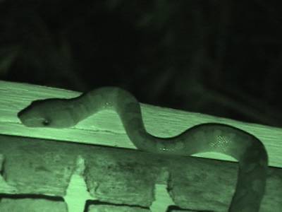
What we believe to be an Epicrates monensis, common name Mona or Virgin Island Tree Boa, was photographed the evening of August 26, 2003 slithering around a balcony of a house in the Mosquito beach area. The other possibility we feel may be less likely, is that it is the Puerto Rican Boa, E. inoratus. If you are a herpitologist and can identify the species from this photo, please comment and let us know what you think. We sent the photos to USFWS in Boqueron for identification and will get back with an ID when we hear what they think it is.
Either boa was listed Appendix I to CITES on 2/4/77. This still photograph was taken from the Aug 26th video shot using a Sony TRV 33 with night shot.

We copied this map from the USFWS letter...see link below and then we indicated in red where the boa was filmed in relation to the beach. This is on the Hill just above the las bacas beach area.
QUIT SQUINTING...YOU CAN CLICK ON PHOTOS OR DOCUMENTS TO ENLARGE.

Where's the rest of him? Hang on it's coming....
Still photo taken from Paul Franklin video

Still photo captured from night shot video on Aug 26, 2003. We believe this to be Epicrates monensis and may prove to be another example of Culebra, or in this case "A Culebra" protecting sea turtles. This is a very pretty snake, the night shot does not do it justice.
Still photo taken from Paul Franklin video

Fish and Wildlife Service Write Letter On Mosquito

Another letter validating our ecological concerns on Playa Mosquito was received from the United States Fish and Wildlife Service, Boqueron office.
To view the letter click on:
http://www.coralations.org/NFWSNov242004.pdf

This is in response to the last letter we wrote, this time to all agencies and in an attempt to facilitate some multi-jurisdictional agency communication on this back in August. The letter actually forcasts the illegal road being cleared.

This letter has photos with circles and arrows....very Alice's Restaurant, enjoy...
http://www.coralations.org/MosquitoAgencies2004.pdf


Thursday, November 25, 2004


FOIA sent to ACE on Nov 24 to see if ACE has issued any endorsment of the activities on the beach to date.

Wednesday, November 24, 2004

Refuse to Create a Querella

At 2:45 my lawyer said to file a querella with the DNER at the Vigilantes Office on Culebra to formerly document the complaint about earth moving with heavy equipment last Friday and Playa Mosquito. There was no implementation of erosion control.

She said if you don't file a formal querella, there is no formal track record of the complaint at the DNER office. This is never easy and today I was not successful.
I got there about 3:15 and requested and requested until 4:00 when they were leaving. No formal complaint was recorded. However, at least they were nice.
Sgt. Feliciano said we should have called on Friday to file the complaint. I explained that I tried but no one was in the office (they got in late becuase it was a holiday.)

He checked his log and confirmed that 10:00 am was first recorded call.
In the phone log was a formal complaint issued by ACDEC, but it is my understanding from this conversation they did not file a formal querella, so my question is, does the complaint go on DNER record?

The Vigilante felt that on Friday the agency successfully intervened and so therefor there was no need for a formal querella.
I explained they may have intervened but if the earth moving took place without at permiso simple and erosin control, what will become of the violation if there is no written record? He said that although he was not involved on Friday, a permiso simple was not needed for the earth they moved. It gets better. . .

I saw no record in the log book of the communication with USFWS Refuge Manager. I called the Refuge Manager on Friday morning by cell phone and she notified the Vigilantes. She does not have jurisdiction here, this it totally DNER. I am confident the local refuge manager contacted them and believe USFWS made a site visit last Friday. I am not confident there is a record of this in the DNER office.

So here we have citizen trying to contact DNER but not successful and two agencies contacting DNER, which there may also not be written record of with DNER. I asked ACDEC on Monday if they had a Permiso Simple, and Hilda Avila from ACDEC told me that they had no permits...nothing.

Today this is what Sgt. Feliciano told me:

1. The property owners had a certificate from the Puerto Rico Institute of Culture. (Remember, there has been no "dig" to find the Taino shell middens unearthed by the well diggers a few years ago and reported in writing to the institute and to Feds. The artifacts were first documented in the area by a Federally comissioned study.

Friday, Taino relics were unearthed by the digger and despite word from agencies that the operator had been stopped, he continued to operate on the beach until 4:30 pm.
ACDEC believed the digger stopped until a DNER Tech came over from the big island to investigate the activity.

2. The Vigilante confirmed that the property owners were clearing for a road, and said he saw permits.........so this is a mystery....since no plans TO OUR KNOWLEDGE have crossed the desk of the coastal zone people. The last plans placed a road inside the wetlands and we understand that the Corps of Engineers has not issued permits for a road to pass through this wetlands.

The last thing this area needs is another unplanned, unengineered illegal road....especially one that impacts the wetlands...check out what current roads are doing to this bay and critical habitat. Please see http://mosquitobaysediment.blogspot.com

3. The Vigilante said there was also a certificate or letter from Army Corps of Engineers when the Corps is telling us that they still need to schedule a site visit before they officially delineate the wetlands! What document are they talking about and shouldn't the other agencies have by now all these permits for validation? We sent a FOIA to the Corps just to make sure that there is no document in the office of the Vigilantes that permits this work in the wetlands.

4. The Vigilante said the technico came back for a site visit on Tuesday Nov 25th, but we see no delineation concsistent with definition of the zmt / public domain on the beach.
I tried to get the name of the Tech and the office the tech came from the Vigilante, but he said he did not have this information.


Tuesday, November 23, 2004

They continue....

Went to Mosquito today to see the clearing.
There was an even larger opening in the vegetation through to the wetlands, and a stake with a string also in the wetland vegetation. What we had heard was almost a complete Taino artifact found on Friday, turned out to be shards...but artifacts none the less.

It is our understanding that....
Maritime zone is still pending delineation from the DNER.
Wetlands are still pending delineation from the Army Corps.
Stake with a string placed in wetlands, was not placed by Army Corps.
Stakes 24 ft from the water's edge are not consistent with the definition of maritime zone, and the reference to it as such by local officials may constitute fraud.
Assuming the homeowners thought this was the delineation, they still cleared all the way to water's edge...
No permiso simple exists for the earth moving that took place last Friday.
No erosion control has been implemented to date.
Clearing is in preparation for a road, on a public beach, that we understand is placed inside the wetlands..which today is illegal.
To date we have seen no new plans submitted through Planning Board coastal zone requesting permits for the new road.
If it is this difficult to control illegal activity inside the maritime zone, imagine trying to prevent damage in upland watershed areas.
For more photos on runoff impacting mosquito bay and to see why we don't need yet another illegal road in this watershed visit: http://mosquitobaysediment.blogspot.com


Note the stake is inside the wetland vegitation.
Photo by Mary Ann Lucking

To date, we understand Army Corps has not yet delineated the wetlands...
Photo by Mary Ann Lucking

Well they continued on Friday, despite the Taino artifacts and agency oversight. Clearing for an unpermitted road just as predicted.
Photo by Mary Ann Lucking

Sunday, November 21, 2004

Stopped or not stopped?

We heard from ACDEC on Friday that they stopped the digger on the beach. They had no permits to clear earth. We also heard from ACDEC that the digger had unearthed an almost complete Taino artifact. ACDEC told us that the operator siad the head vigilante was giving verbal permission to clear earth. There are no written permits and this head vigilanted is not authorized to give such permission, but we have seen this in the past with the illegal development on top of Mt. Resaca. We took Resaca to court (which had permits) and judged ruled that their permits were in fact illegal.

To our surprise, we just heard from beach neighbors (today is Sunday) that the digger apparently continued until 4:30 Friday afternoon!

USFWS wrote an email stating the Regional Office from DNER will be visiting again on Monday to determine once and for all where the Public Domain is....the Maritime Zone.
I guess there waiting for all the clearing to be completed.

Again this is endangered sea turtle nesting beach, endagered boa habitat, resource Cat 1 sea grass offshore and no permits for clearing earth and still no implementation of erosion control. Taino artifacts were mentioned in our letters to the agencies, as a study done years ago placed artifacts on this beach.

This is amazing that they continue despite the government intervention.

Pictures coming....

Friday, November 19, 2004

DNER ARE THE ONLY ONES WHO CAN TAKE ACTION

DNER of Puerto Rico are apparently the only ones who have the jurisdictional authority to stop this illegal digger in Playa Mosquito.
This brings up the following questions....
Do they have a Permiso Simple to move earth from the Agency?
Is this permit excempt from the implementation of erosion control? No erosion control has been implemented to date.
What about the ZMT? We have no response from the agency or documentation that ZMT has been delineated. We have had verbal confirmation from the Department that it has not.

Why is there no way to contact DNER enforcement personnel on a holiday?

Teresa Tallevast, USFWS Refuge manager took immediate action to try and contact them and Hilda Avila from the Culebra Conservation and Development Authority was notified and called back confirming she received the message on the problem on a Holiday. Go you guys!
Copy of email message from Refuge Manager. . . . .
--------------------------------------------------------------------------
Subject: digger
To: coralations@yahoo.com
From: Teresa_Tallevast@fws.gov Add to Address Book
Date: Fri, 19 Nov 2004 07:55:11 -0400

MA I called the police and everybody. Today is a PR holiday, if the
vigilantes don't get into work at 8:00 Benjamin Maldonado told me that
he will go with me to the site. But DNER needs to be there. i called
Hector too. Teresa


Here you can just see the top of the digger heading for the trees right where the illegal road was predicted to be cleared.
Photos por Mary Ann Lucking, Nov 19, 2004

Digger on Beach..Happy Holidays!

Yes, it is a holiday so try to get a hold of the local DNER today.
It appears that reports of Marcos stopping them...were greatly exaggerated.

This morning they began moving earth with a digger on the beach.
In the past heavy equipment was used on this beach to explore for wells and to uproot and remove trees.

What this place does not need is yet another illegal road.
http://mosquitobaysediment.blogspot.com


Digger moving earth on Playa Mosquito.
Photos por Mary Ann Lucking, Nov 19, 2004

Digger emerges from beach scooping earth.
Photos por Mary Ann Lucking, Nov 19, 2004

Digger emerges from beach. It is apparently moving soil toward the cliff.
Photos por Mary Ann Lucking, Nov 19, 2004

Thursday, November 18, 2004

Deforestation Continues

Deforestation continues on the beach at Playa Mosquito. In August a letter was sent to all agencies from CORALations regarding this very concern. Although we are not sure, we believe it is clearing for a private access road and parking for six of the SE Harbor Homeowner Association members that claim private deeded acce$$ to this (public) beach.

Previous plans placed a road and parking lot inside the wetlands! Hey I've heard of selling swamp land in Florida but a private deeded access road and parking lot, in the wetlands and in PR... where all beaches and access are public....this one takes the cake!
Well someone took the cake.... and ran away eating it!

Is this clearing for a road and if so....does the road have permits?

The species losing habitat in this deal are the endangered tree boas, endangered migratory sea birds, migratory birds, birds in general, nesting habitat for the endangered Hawksbill sea turtles, and, of course, the critically endangered public domain.

The good news is there were no diggers on the beach today. There was no uprooting of trees. There were three workers apparently brought in from the big island to clear out tproperty.

More on impacts at Mosquito beach can be found at: http://mosquitobaysediment.blogspot.com


Deforestation Stopped Today

This morning we were told that the DNER Vigilantes stopped the clearing on Playa Mosquito.

We were told they are waiting for another visit from the Regional Office Technician to evaluate what is going on next week.


Wednesday, November 17, 2004


Playa Mosquito Today
Photos by Mary Ann Lucking Nov 17, 2004

A view from shore of Playa Mosquito today.
Photos by Mary Ann Lucking Nov 17, 2004

Zoom of the clearing with wetland vegitation.
Photos by Mary Ann Lucking Nov 17, 2004

The clearing of beach opened into the wetlands, however no heavy equipment was used today.
Photos by Mary Ann Lucking Nov 17, 2004